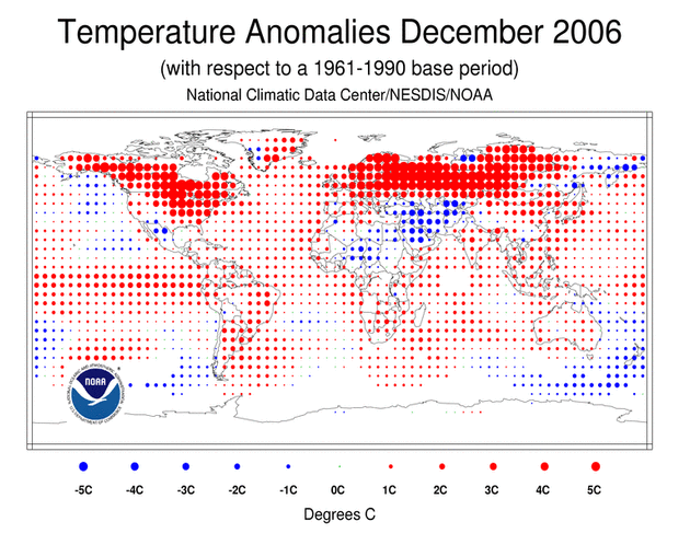
Graphic from the National Climatic Data Center. From Dr. Jeff Masters' WunderBlog WunderBlog:
The average global temperature for December 2006 was +0.72°C (+1.30°F) above normal, beating out 2003's record of +0.70°C/1.26°F, according to the National Climatic Data Center. Much of the U.S., Canada, Europe, and Siberia recorded their warmest December ever. Below normal temperatures were recorded in the Middle East and northern Africa, but over 80% of the world’s land areas were warmer than average--and not just a little above average! The swath of temperatures more than 5°C (9 °F) above average covering most of the world’s land mass north of 40° north latitude is unprecedented in size in the wintertime historical record, going back to at least 1900.
Record winter warmth in one part of the Northern Hemisphere is usually due to a sharp bend in the jet stream that creates a ridge of high pressure, allowing a warm southerly flow of air into the region. Adjacent regions have a compensating trough of low pressure that brings cold, northerly winds and below normal temperatures. This was certainly the case in January 2006, when the U.S. experienced its warmest January on record. Asia and Europe experienced a brutally cold January. Moscow hit -40°, its coldest temperature since 1979. Parts of Portugal saw their first snow since 1954. Siberia reached -70° F.
Enter December 2006. Again, record warmth was observed over the U.S. and Canada. A compensating cooler than normal area was present over the Gulf of Alaska and western Siberia, but it was very weak. There was almost no cold Arctic air present anywhere in the Northern Hemisphere, which is unprecedented in the historical record (going back at least 100 years). What’s the cause of this unusual pattern? Part of the blame probably rests with the late-freezing Arctic ice this year. More open water than ever recorded pumped abnormal heat and moisture into the air, retarding the formation of the usual cold air masses. At an interesting talk titled “Extremes and El Nino” given by Dr. Gerald Meehl of the National Center for Atmospheric Research today, he showed that both El Nino and increasing greenhouse gases are probably part of the reason, as well. He averaged together the wintertime temperature anomalies for El Nino events for the 1970s through 1990s, and came up with a plot that showed the typical pattern we expect--a warm winter over Canada and the northern U.S., and cold over Europe and Asia. Next, he showed a climate model simulation of a wintertime El Nino event run using the levels of greenhouse gases that we have now. The model simulation showed wintertime warmth extending into Asia and Europe during El Nino years, much like the pattern in Figure 1, thanks to the increase in greenhouse gases over the past 30 years.
No comments:
Post a Comment