Climatologist Who Predicted California Drought 10 Years Ago Says It May Soon Be ‘Even More Dire’

“Where the sea ice is reduced, heat transfer from the ocean warms the atmosphere, resulting in a rising column of relatively warm air,” Sewall said. “The shift in storm tracks over North America was linked to the formation of these columns of warmer air over areas of reduced sea ice.” In January, Sewall wrote me that “both the pattern and even the magnitude of the anomaly looks very similar to what the models predicted in the 2005 study (see Fig. 3a [below]).”
Here is what Sewall’s model predicted in his 2005 paper:

“Geopotential height” is the height above mean sea level for a given pressure level. The “500 mb level is often referred to as the steering level as most weather systems and precipitation follow the winds at this level,” which is around 18,000 feet.
Now here is what the 500 mb geopotential height anomaly looked like over the last year, viaNOAA:

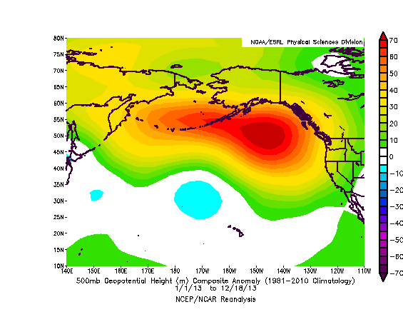
That is either a highly accurate prediction or one heck of a coincidence.
Last year, I contacted Sloan to ask her if she thought there was a connection between the staggering loss of Arctic sea ice in recent years and the brutal drought gripping the West, as her research predicted. She wrote, “Yes, sadly, I think we were correct in our findings, and it will only be worse with Arctic sea ice diminishing quickly.” Last week, Sloan wrote me:
Yes, in this case I hate that we (Sewall & Sloan) might be correct. And in fact, I think the actual situation in the next few decades could be even more dire that our study suggested. Why do I say that? (1) we did not include changes in greenhouse gases other than CO2; (2) maybe we should have melted more sea ice and see what happens; (3) these atmospheric and precipitation estimates do not include changes in land use, in the US and elsewhere. Changing crops, or urban sprawl increases, or melting Greenland and Northern Hemisphere glaciers will surely have an impact on precipitation patterns.
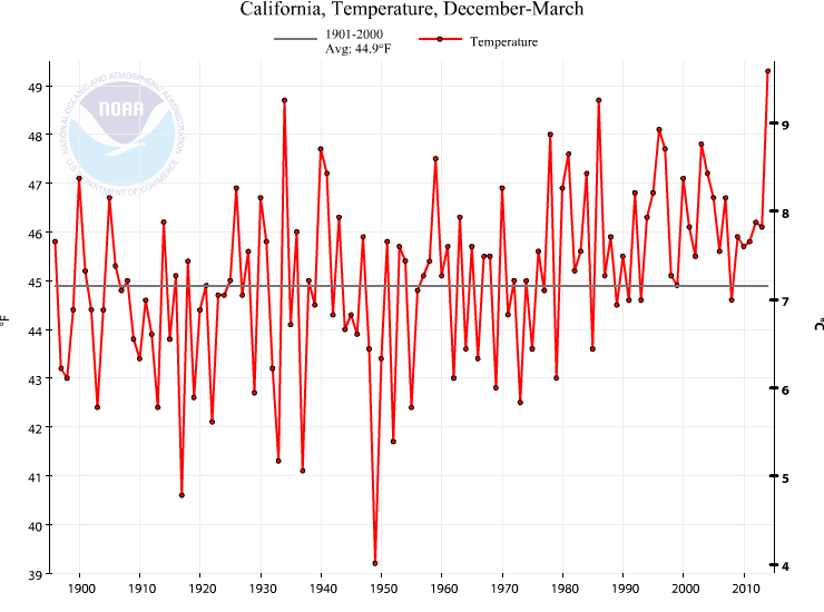
2013-2014 was California’s warmest winter on record. (NOAA/NCDC)
The increasing trend in annual temperature in California over the past 118 years. (Source: NOAA). This trend mirrors the global increase.
_____________________________________________
_____________________________________________
From UJ:
This same phenomena that is causing the California drought is causing Alaska to get more warm air, which would warm the arctic more (presumably). It also is what pushed cold air down to the Midwest / Great Lakes region this past winter - referred to as the Polar Vortex. We had near record snowfalls, and were colder than usual. It also took longer than normal (by 3-4 weeks) for Spring to get here this year.
It is interesting to see the world as whole - departures from normal - below:
No comments:
Post a Comment