Thursday, July 26, 2012

"Greenland ice sheet melted at unprecedented rate during July"

From the Guardian.UK:
"Scientists at Nasa admitted they thought satellite readings were a mistake after images showed 97% surface melt over four days"
Greenland ice sheet composite.View larger picture
The Greenland ice sheet on July 8, left, and four days later on the right. In the image, the areas classified as 'probable melt' (light pink) correspond to those sites where at least one satellite detected surface melting. The areas classified as 'melt' (dark pink) correspond to sites where two or three satellites detected surface melting. Photograph: Nasa

The Greenland ice sheet melted at a faster rate this month than at any other time in recorded history, with virtually the entire ice sheet showing signs of thaw.
The rapid melting over just four days was captured by three satellites. It has stunned and alarmed scientists, and deepened fears about the pace and future consequences of climate change....
The set of images released by Nasa on Tuesday show a rapid thaw between 8 July and 12 July. Within that four-day period, measurements from three satellites showed a swift expansion of the area of melting ice, from about 40% of the ice sheet surface to 97%.
Scientists attributed the sudden melt to a heat dome, or a burst of unusually warm air, which hovered over Greenland from 8 July until 16 July.
Greenland had returned to more typical summer conditions by 21 or 22 July, Mote told the Guardian.
But he said the event, while exceptional, should be viewed alongside other compelling evidence of climate change, including on the ground in Greenland.
"What we are seeing at the highest elevations may be a sort of sign of what is going on across the ice sheet," he said. "At lower elevations on the ice sheet, we are seeing earlier melting, melting later in the
season, and more frequent melting over the last 30 years and that is consistent of what you would expect with a warming climate."
Zwally, who has made almost yearly trips to the Greenland ice sheet for more than three decades, said he had never seen such a rapid melt.
About half of Greenland's surface ice sheet melts during a typical summer, but Zwally said he and other scientists had been recording an acceleration of that melting process over the last few decades. This year his team had to rebuild their camp, at Swiss Station, when the snow and ice supports melted.
_____

Meltwater from Greenland glacier wipes out key crossing

Scientists in Kangerlussuaq on western edge of ice sheet film runoff from glacier washing out roads and taking out a tractor

US Drought Monitor 7-24-2012

droughtmonitor.unl.edu/

I live in one of the "exceptional" areas - so this is hitting home. 
___
From weather.com:
The 2012 drought disaster is rapidly worsening in severity, especially over the nation's agricultural heartland, according to the latest weekly U.S. Drought Monitor report, released Thursday.While the area covered by the overall drought grew only slightly, the intensity increased alarmingly. 
Nationally, the percentage of the country in "extreme" to "exceptional" drought – the two worst categories on the scale – jumped from 13.53% to 20.57%. In other words, another 219,000 square miles was added to the area in extreme drought – an area slightly larger than the states of California and New York combined. 
All percentage figures refer to the contiguous 48 states: 
- The percentage of the country in "severe" drought (level 2) or worse set a new 21st-century high for the second straight week, rising from 42.23% last week to 45.57% this week. 
- The percentage of country in "exceptional" drought climbed from 0.99% last week to 2.38% this week – a considerable jump, but still well below the levels in the 2011 Southern Plains drought.

"Weather Extremes Leave Parts of U.S. Grid Buckling"


WASHINGTON — From highways in Texas to nuclear power plants in Illinois, the concrete, steel and sophisticated engineering that undergird the nation’s infrastructure are being taxed to worrisome degrees by heat, drought and vicious storms.
On a single day this month here, a US Airways regional jet became stuck in asphalt that had softened in 100-degree temperatures, and a subway train derailed after the heat stretched the track so far that it kinked — inserting a sharp angle into a stretch that was supposed to be straight. In East Texas, heat and drought have had a startling effect on the clay-rich soils under highways, which “just shrink like crazy,” leading to “horrendous cracking,” said Tom Scullion, senior research engineer with the Texas Transportation Institute at Texas A&M University. In Northeastern and Midwestern states, he said, unusually high heat is causing highway sections to expand beyond their design limits, press against each other and “pop up,” creating jarring and even hazardous speed bumps.
Excessive warmth and dryness are threatening other parts of the grid as well. In the Chicago area, a twin-unit nuclear plant had to get special permission to keep operating this month because the pond it uses for cooling water rose to 102 degrees; its license to operate allows it to go only to 100. According to the Midwest Independent System Operator, the grid operator for the region, a different power plant had had to shut because the body of water from which it draws its cooling water had dropped so low that the intake pipe became high and dry; another had to cut back generation because cooling water was too warm.
The frequency of extreme weather is up over the past few years, and people who deal with infrastructure expect that to continue. Leading climate models suggest that weather-sensitive parts of the infrastructure will be seeing many more extreme episodes, along with shifts in weather patterns and rising maximum (and minimum) temperatures.
“We’ve got the ‘storm of the century’ every year now,” said Bill Gausman, a senior vice president and a 38-year veteran at the Potomac Electric Power Company, which took eight days to recover from the June 29 “derecho” storm that raced from the Midwest to the Eastern Seaboard and knocked out power for 4.3 million people in 10 states and the District of Columbia.
In general, nobody in charge of anything made of steel and concrete can plan based on past trends, said Vicki Arroyo, who heads the Georgetown Climate Center at Georgetown University Law Center in Washington, a clearinghouse on climate-change adaptation strategies.
Highways, Mr. Scullion noted, are designed for the local climate, taking into account things like temperature and rainfall. “When you get outside of those things, man, all bets are off.” As weather patterns shift, he said, “we could have some very dramatic failures of highway systems.”
Adaptation efforts are taking place nationwide. Some are as huge as the multibillion-dollar effort to increase the height of levees and flood walls in New Orleans because of projections of rising sea levels and stronger storms to come; others as mundane as resizing drainage culverts in Vermont, where Hurricane Irene damaged about 2,000 culverts. “They just got blown out,” said Sue Minter, the Irene recovery officer for the state.
In Washington, the subway system, which opened in 1976, has revised its operating procedures. Authorities will now watch the rail temperature and order trains to slow down if it gets too hot. When railroads install tracks in cold weather, they heat the metal to a “neutral” temperature so it reaches a moderate length, and will withstand the shrinkage and growth typical for that climate. But if the heat historically seen in the South becomes normal farther north, the rails will be too long for that weather, and will have an increased tendency to kink. So railroad officials say they will begin to undertake much more frequent inspection.
Some utilities are re-examining long-held views on the economics of protecting against the weather. Pepco, the utility serving the area around Washington, has repeatedly studied the idea of burying more power lines, and the company and its regulators have always decided that the cost outweighed the benefit. But the company has had five storms in the last two and a half years for which recovery took at least five days, and after the derecho last month, the consensus has changed. Both the District of Columbia and Montgomery County, Md., have held hearings to discuss the option — though in the District alone, the cost would be $1.1 billion to $5.8 billion, depending on how many of the power lines were put underground.
Even without storms, heat waves are changing the pattern of electricity use, raising peak demand higher than ever. That implies the need for new investment in generating stations, transmission lines and local distribution lines that will be used at full capacity for only a few hundred hours a year. “We build the system for the 10 percent of the time we need it,” said Mark Gabriel, a senior vice president of Black & Veatch, an engineering firm. And that 10 percent is “getting more extreme.”...
Ms. Arroyo of Georgetown said the federal government must do more. “They are not acknowledging that the future will look different from the past,” she said, “and so we keep putting people and infrastructure in harm’s way.”

Wednesday, July 25, 2012

"Beijing's worst storms for 60 years kill at least 37"

From the Guardian.UKFlooded streets in Beijing after China's heaviest rain in six decades, with up to 460mm (18in) falling in some places since Saturday Link to this video
The heaviest rainstorm in Beijing in six decades has killed at least 37 people, flooded streets and stranded 80,000 people at the main airport, state media and the government said on Sunday.
The storm, which started on Saturday afternoon and continued late into the night, flooded major roads and sent torrents of water tumbling down steps into underpasses.
The Beijing city government said on its official microblog that at least 37 people had died, including 25 drowned, six crushed in collapsing homes, five electrocuted and one struck by lightning.
More than 500 flights were cancelled at Beijing's Capital International Airport, the Beijing News added.
The subway system was largely unaffected by the floods but was swamped with people desperate to get home and unable to use cars, buses or taxis.
The city received about 170mm (6.7 inches) of rain on average, but one township in Fangshan District to Beijing's west was hit by 460mm, Xinhua news agency said.
The Beijing city government said on its website it was working to get the metropolis back on its feet, and warned people to prepare for further bad weather.
"The weather forecasters say that from late July to early September this city is prone to flooding, and there could be further large-scale storms or extreme weather," it said.

Thursday, July 19, 2012


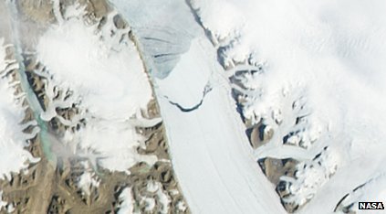
Iceberg twice the size of Manhattan breaking off the Peterman Glacier in Greenland. AP/NASA image.

Nice Transit of Venus Video

Video from NOAA Satellite

The Heat Goes On


 The US drought with record high temperatures continues. Other places like the UK are having record rainfall. Japan also had severe flooding from the rain.

Record High Temps in Red (lows in blue) 7-17--7-19

101 degrees on one side of the rain, 74 degrees on the other


This is corn in Brownsburg, IN.
The rain events have been spottier than usual. A small storm popping up, dropping a little rain, dissipating.

We hear thunder and get a few drops.

The map with the weather stations is from a couple of days ago - a storm got some areas and temporarily a relief from the 100 degree heat.

Owen County, Indiana, where I live, is in the official disaster area.

Fortunately we continue to have water in our well. We aren't wasting any (much). I water a few pots and recently planted blueberries a little. We hope we can make it until the drought is over (I hope it will be over).

Much is dry. The grass doesn't grow - we don't worry about it. Most of the established trees seem fine. Some have dried and dropped some leaves already.

Farmers are having a tough time.

The dried up lake with boats is Morse Reservoir - just north of Indianapolis. It's not completely dried up - just the shallower parts. Morse, Geist and Eagle Creek are where Indy gets their water.


Morse Reservoir showing drought effects


Saturday, June 30, 2012

It's hot.... and dry

We could use some rain.


Thursday's significant temperature records:

• 109° in Chesterfiled, Missouri (well short of state monthly record of 112°)• 108° in Lawrenceville, Illinois (ties all-time state June monthly record of 108° at Palestine in June 1954)• 108° in Huntingsburg, Indiana (well short of state monthly record of 111°)• 107° in Defiance, Ohio (1° short of all-time state June record-108° in Germantown in 1934)• 111° in Evening Shade, Arkansas (short of state June record of 113° in 1936)• 108° in Smyrna, Tennessee (short of 110° state record in 1936)• 107° in Little Rock, Arkansas (all-time June monthly record)
From the Weather Underground - Jeff Masters
The Amazing June Heat Wave of 2012

One of the most intense heat waves in U.S. history has enveloped portions of the western plains and Midwest and has now spread eastward. All-time heat records have fallen at a number of significant weather stations. And it is still just June. Is this a prelude for the coming summer or just a flash in the pan? 

June had been a warm but not excessively so month until around June 20-23rd when an upper level high pressure dome that had been centered over the Baja of Mexico began to move/expand northeastward and strengthen dramatically. Between June 23 and June 27 this dome remained nearly stationary over the southern plains and maintained its strength.


The water vapor image for 3Z on June 23 shows a deep trough over the Pacific Ocean west of California amplifying the high pressure ridge over the southwest and southern plains. Image from UNYSYS GOES West satellite.


he air aloft became so abnormally warm that the NWS office in Dodge City focused on how intense the air aloft was in their daily discussions. At the 850 millibar level (about 5000’) the temperature was averaging an amazing 30°C (86°F) at the 5 a.m. (12Z) observation times on June 23-27!

The heat at surface level reached its greatest extent on June 26th, although the period of all-time records broken ranged from June 23 to June 27.

Here is a surface temperature map for 5p.m CST time on June 26:


Could this be the Beginning of Another ‘Summer of 1936'?

The only previous June heat waves in U.S. history that compare to the current one were those of 1934, 1936, and 1954. The summer of 1934 went on to be the warmest on record for the U.S. (74.6° June-August average) and July 1936 the single hottest month on record (77.4° average).

Ominously, some of the June records that have so far been set this month have eclipsed those of June 1934 and 1936 (1954 turned out be a summer of only slightly above long-term average normal temperature).


From the Weather Underground blog - by  Christopher C. Burt

Saturday, June 23, 2012

" Corporate Profits Just Hit An All-Time High, Wages Just Hit An All-Time Low"

Corporate profit margins just hit an all-time high. Companies are making more per dollar of sales than they ever have before. (And some people are still saying that companies are suffering from "too much regulation" and "too many taxes." Maybe little companies are, but big ones certainly aren't)

Wages as a percent of the economy are at an all-time low. This is both cause and effect. One reason companies are so profitable is that they're paying employees less than they ever have as a share of GDP. And that, in turn, is one reason the economy is so weak: Those "wages" are other companies' revenue.

---------------------------------

Of course it wouldn't have to be like this. 

Sea Level Rise in the Coming Centuries

From the University of Copenhagen:
“Based on the current situation we have projected changes in sea level 500 years into the future. We are not looking at what is happening with the climate, but are focusing exclusively on sea levels”, explains Aslak Grinsted, a researcher at the Centre for Ice and Climate, the Niels Bohr Institute at the University of Copenhagen.

The research group has made calculations for four scenarios: A pessimistic one, where the emissions continue to increase. This will mean that sea levels will rise 1.1 meters by the year 2100 and will have risen 5.5 meters by the year 2500.Even in the most optimistic scenario, which requires extremely dramatic climate change goals, major technological advances and strong international cooperation to stop emitting greenhouse gases and polluting the atmosphere, the sea would continue to rise. By the year 2100 it will have risen by 60 cm and by the year 2500 the rise in sea level will be 1.8 meters. For the two more realistic scenarios, calculated based on the emissions and pollution stabilizing, the results show that there will be a sea level rise of about 75 cm and that by the year 2500 the sea will have risen by 2 meters. 

Sunday, May 13, 2012

Study links biodiversity and language loss/ nature and culture


The decline of linguistic and cultural diversity is linked to the loss of biodiversity, a study has suggested.
The authors said that 70% of the world's languages were found within the planet's biodiversity hotspots.
Data showed that as these important environmental areas were degraded over time, cultures and languages in the area were also being lost.
The results of the study have been published in the Proceedings of the National Academy of Sciences (PNAS).
"Biologists estimate annual loss of species at 1,000 times or more greater than historic rates, and linguists predict that 50-90% of the world's languages will disappear by the end of the century," the researchers wrote...
"We used improved language data to really get a more solid sense of how languages and biodiversity co-occurred and an understanding of how geographically extensive the language was."
He said the study achieved this by also looking at smaller areas with high biodiversity, such as national parks or other protected habitats.
"When we did that, not only did we get a sense of co-occurrence at a regional scale, but we also got a sense that co-occurrence was found at a much finer scale," he said.
"We are not quite sure yet why this happens, but in a lot of cases it may well be that biodiversity evolved as part-and-parcel of cultural diversity, and vice versa."
In their paper, the researchers pointed out that, out of the 6,900 or more languages spoken on Earth, more than 4,800 occurred in regions containing high biodiversity....


Friday, May 04, 2012

"Climate Change Trends: Carbon Emissions Giants"

Nice Resource from NPR - interactive maps with info. Showing emissions by country, emissions per person, population growth + coal reserves, more


Right now, 10 countries — including the U.S., China and Russia — are responsible for 80 percent of the world's carbon dioxide emissions. The United States is the world's second largest emitter (China ranks no. 1), sending around 5.8 million metric tons of CO2 into the atmosphere a year. That's the equivalent to a year's worth of greenhouse gas emissions from 1.1 billion average passenger vehicles. Below, a look at today's big CO2 emitters — and projected emissions giants in 2030.

Tuesday, April 17, 2012

Fate of Japan and the Whole World Depends on No. 4 Reactor

By Akio Matsumura, Finding the Missing Link
11 April 12

Fukushima Daiichi site: Cesium-137 is 85 times greater than at Chernobyl accident.
rsn-J.jpgapan’s former Ambassador to Switzerland, Mr. Mitsuhei Murata, was invited to speak at the Public Hearing of the Budgetary Committee of the House of Councilors on March 22, 2012, on the Fukushima nuclear power plants accident. Before the Committee, Ambassador Murata strongly stated that if the crippled building of reactor unit 4 - with 1,535 fuel rods in the spent fuel pool 100 feet (30 meters) above the ground - collapses, not only will it cause a shutdown of all six reactors but will also affect the common spent fuel pool containing 6,375 fuel rods, located some 50 meters from reactor 4. In both cases the radioactive rods are not protected by a containment vessel; dangerously, they are open to the air. This would certainly cause a global catastrophe like we have never before experienced. He stressed that the responsibility of Japan to the rest of the world is immeasurable. Such a catastrophe would affect us all for centuries. Ambassador Murata informed us that the total numbers of the spent fuel rods at the Fukushima Daiichi site excluding the rods in the pressure vessel is 11,421  (396+615+566+1,535+994+940+6375).
I asked top spent-fuel pools expert Mr. Robert Alvarez, former Senior Policy Adviser to the Secretary and Deputy Assistant Secretary for National Security and the Environment at the U.S. Department of Energy, for an explanation of the potential impact of the 11,421 rods.
I received an astounding response from Mr. Alvarez [updated 4/5/12]:
In recent times, more information about the spent fuel situation at the Fukushima-Dai-Ichi site has become known. It is my understanding that of the 1,532 spent fuel assemblies in reactor No. 304 assemblies are fresh and unirradiated. This then leaves 1,231 irradiated spent fuel rods in pool No. 4, which contain roughly 37 million curies (~1.4E+18 Becquerel) of long-lived radioactivity. The No. 4 pool is about 100 feet above ground, is structurally damaged and is exposed to the open elements. If an earthquake or other event were to cause this pool to drain this could result in a catastrophic radiological fire involving nearly 10 times the amount of Cs-137 released by the Chernobyl accident.
The infrastructure to safely remove this material was destroyed as it was at the other three reactors. Spent reactor fuel cannot be simply lifted into the air by a crane as if it were routine cargo. In order to prevent severe radiation exposures, fires and possible explosions, it must be transferred at all times in water and heavily shielded structures into dry casks.. As this has never been done before, the removal of the spent fuel from the pools at the damaged Fukushima-Dai-Ichi reactors will require a major and time-consuming re-construction effort and will be charting in unknown waters. Despite the enormous destruction cased at the Da-Ichi site, dry casks holding a smaller amount of spent fuel appear to be unscathed.
Based on U.S. Energy Department data, assuming a total of 11,138 spent fuel assemblies are being stored at the Dai-Ichi site, nearly all, which is in pools. They contain roughly 336 million curies (~1.2 E+19 Bq) of long-lived radioactivity. About 134 million curies is Cesium-137 - roughly 85 times the amount of Cs-137 released at the Chernobyl accident as estimated by the U.S. National Council on Radiation Protection (NCRP). The total spent reactor fuel inventory at the Fukushima-Daichi site contains nearly half of the total amount of Cs-137 estimated by the NCRP to have been released by all atmospheric nuclear weapons testing, Chernobyl, and world-wide reprocessing plants (~270 million curies or ~9.9 E+18 Becquerel).
It is important for the public to understand that reactors that have been operating for decades, such as those at the Fukushima-Dai-Ichi site have generated some of the largest concentrations of radioactivity on the planet.
Many of our readers might find it difficult to appreciate the actual meaning of the figure, yet we can grasp what 85 times more Cesium-137 than the Chernobyl would mean. It would destroy the world environment and our civilization. This is not rocket science, nor does it connect to the pugilistic debate over nuclear power plants. This is an issue of human survival.
There was a Nuclear Security Summit Conference in Seoul on March 26 and 27, and Ambassador Murata and I made a concerted effort to find someone to inform the participants from 54 nations of the potential global catastrophe of reactor unit 4. We asked several participants to share the idea of an Independent Assessment team comprised of a broad group of international experts to deal with this urgent issue.
I would like to introduce Ambassador Murata’s letter to the UN Secretary General Ban Ki-moon to convey this urgent message and also his letter to Japan’s Prime Minister Yoshihiko Noda for Japanese readers. He emphasized in the statement that we should bring human wisdom to tackle this unprecedented challenge.
It seems to us that the Nuclear Security Summit was focused on the North Korea nuclear issue and on the issue of common security from a terrorist attack. Our appeal on the need for the independent assessment at Reactor 4 was regarded as less urgent. We predicted this outcome in light of the nature of the Summit. I suppose most participants fully understood the potential disaster which will affect their countries. Nevertheless, they decided not to raise the delicate issue, perhaps in order to not ruffle their diplomatic relationship with Japan.
I was moved by Ambassador Murata’s courage in pressing this issue in Japan. I know how difficult it is for a former career diplomat to do this, especially in my country. Current and former government officials might be similarly restricted in the scope of their actions, as Ambassador Murata is, but it is their responsibility to take a stand for the benefit of our descendants for centuries to come - to pass on a world safer than our ancestors passed us.
If Japanese government leaders do not recognize the risk their nation faces, how could the rest of us be persuaded of the looming disaster? And if the rest of us do not acknowledge the catastrophe we collectively face, who will be the one to act?


Radioactive particles from Japan detected in California kelp


Fukushima Daiichi nuclear power station
From the LA Times:

Radioactive particles released in the nuclear reactor meltdown in Fukushima, Japan, following the March 2011 earthquake and tsunami were detected in giant kelp along the California coast, according to a recently published study.
Radioactive iodine was found in samples collected from beds of kelp in locations along the coast from Laguna Beach to as far north as Santa Cruz about a month after the explosion, according to the study by two marine biologists at Cal State Long Beach. 
The levels, while most likely not harmful to humans, were significantly higher than measurements prior to the explosion and comparable to those found in British Columbia, Canada, and northern Washington state following the Chernobyl disaster in 1986, according to the study published in March in the journal Environmental Science & Technology. 
Giant kelp, or Macrocystis pyrifera, is a particularly good measure of radioactive material in the environment because it accumulates iodine, researchers said. They wrote that radioactive particles released into the atmosphere, in particular radioactive isotope iodine 131, made its way across the Pacific, then was likely deposited into the ocean during a period of significant rain shortly after the meltdown in Japan. 
The highest levels were found in Corona del Mar. Researchers wrote that the levels were probably highest there because the kelp is also exposed to urban runoff, which may have increased the amount of rainfall it received.

The study’s authors said that while the effect of radioactive material in kelp is not well known, it would have been consumed by organisms that feed on the kelp such as sea urchins or crustaceans. Certain species of fish, including opaleye, halfmoon or senorita may be particularly affected because their endocrine systems contain iodine, according to researchers. 
"Radioactivity is taken up by the kelp and anything that feeds on the kelp will be exposed to this also,"  Steven Manley, the study's lead author, said in a statement released by Cal State Long Beach. "It enters the coastal food web and gets dispersed over a variety of organisms ...  It's not a good thing, but whether it actually has a measureable detrimental effect is beyond my expertise." 

Jellyfish blooms creating oceans of slime


We here at Universal Jellyfish have been on top of this for awhile. If people decide to get serious about eating them - that would probably take care of it.


Here is a BBC article with updates:


In the last decade enormous plagues of jellyfish have been taking over the seas. And it is our fault. 
As I rose to a couple of metres below the surface, I saw the problem too late: the shallow water was carpeted with mauve stinger jellyfish (Pelagia noctiluca). There was no avoiding it, reaching the surface meant I had to swim through the flames of stingers....
Locals told me the carpet of jellyfish, known as a bloom, was not an isolated case. My dive instructor said he had seen massive blooms off the coast of Gozo every year since 2000. But never before then.
In fact, huge annual jellyfish blooms have been cropping up not just across the Mediterranean, but also the Black Sea, the Gulf of Mexico, and the Yellow and Japan Seas.  Is this a bizarre blip in the continually changing balance of oceanic life, or the beginnings of a new state change in marine diversity?Or in other words: in the Anthropocene, will the seas be filled with slime?If they are, we face some serious problems.
Last year alone, nuclear power plants in Scotland, Japan, Israel and Florida, and also a desalination plant in Israel, were forced to shutdown because jellyfish were clogging the water inlets. The entire Irish salmon industry was wiped out in 2007 after a plague of billions of mauve stingers – covering an area of 10 sq miles (26 sq km) and 35ft (11m) deep – attacked the fish cages. Two years later, a fish farm in Tunisia lost a year's production of sea bream and sea bass after jellyfish invasions. 
Perhaps the most extraordinary blooms have been those occurring in waters off Japan. There, refrigerator-sized gelatinous monsters called Nomuras, weighing 485lb (220 kg) and measuring 6.5ft (2m) in diameter, have swarmed the Japan Sea annually since 2002, clogging fishing nets, overturning trawlers and devastating coastal livelihoods. These assaults have cost the Japanese fisheries industry billions of yen in losses. 

Marine ecologists are warning of worse to come, and pointing the tentacle of blame at us. Some researchers fear that human changes to the marine environment may be leading to a tipping point in which jellyfish will rule the oceans, much as they did hundreds of millions of years ago in pre-Cambrian times. In 2009, Australian marine scientist Anthony Richardson and his colleagues published a research paper entitled The jellyfish joyride, in which they warn that if we do not act to curb current blooms, we will experience runaway populations that will cause open oceanic ecosystems to flip from ones dominated by fish biodiversity to ones dominated by jellyfish.
 
The problem is that no one really knows what causes the blooms. Some believe that population explosions result from overfishing of their dining competitors and predators, which include more than 100 species of fish, and animals such as turtles. However, other researchers point out that overfishing also hits jellyfish by reducing their food availability.Either way, what is clear is that jellyfish are simply better prepared than other marine life for many of the ways humans are changing the ocean environment, such as warmer temperatures, salinity changes, ocean acidification and pollution. In this sense, humans might be jellyfishes’ best friend. 
For instance, pollution can cause algal blooms that reduce the water's oxygen content. This hits muscular swimmers like fish hard, but jellyfish can cope far better with these conditions. 

Warmer water encourages jellyfish reproduction, and they can also better tolerate population crashes because their reproductive strategies are complex and adaptable. Some species of jelly can clone themselves, whereas others reproduce sexually but also have a polyp stage – like corals, with which they are related – that allows large populations of immature individuals to multiply while waiting for the right conditions to mature into adulthood. In these ways, they can withstand impacts that devastate other marine species.
 
Even the coastal infrastructure we build seems to be working to their advantage. Rob Condon, a marine scientist at Dauphin Island Sea Lab in Alabama, says that the pontoons, piers and even drilling platforms help provide anchors for jellyfish polyps, encouraging local population explosions.... 
Gathering data on jellyfish, though, is notoriously difficult. Although 70% of the planet is covered by ocean, we really only have a hazy idea about most of the life outside of coastal or estuarine zones. Jellyfish, which inhabit open oceans and deep waters, are still an enigma in many ways. Monitoring individuals and blooms cannot be done by satellite because they are so transparent, have very low biomass, and often occupy waters below the optical depth for satellite penetration. Even finding polyps and larvae in sea grass is tricky. So, despite JEDI's efforts, no one can say for sure whether blooms are increasing or not.... 

Perhaps one solution is to sustainably exploit their abundance. Jellyfish do have their uses: in collagen preparations (to treat rheumatoid arthritis, for example), they are popular attractions in aquaria, and their fluorescent proteins have been instrumental in biomedical discoveries.
 
And, of course, they are a source of food. In Japan and other parts of Asia, jellyfish are dried and chopped into noodle-like strips to be added to soups, for example. Some entrepreneurial Japanese are even making vanilla-and-jellyfish ice cream. Jellyfish are 80% protein and very low in fat, although the high sodium content probably outweighs their health benefits.